 I must go down to the seas again,
To the lonely sea and the sky.
And all I want is a tall ship,
And a star to steer her by.
~ John Masefield
Suppose you lived in olden times and you joined a fleet of wooden ships and iron men. Or maybe it’s wooden teeth and dirty old men. Whichever. But if you didn’t know the basics of using a star to steer a tall ship, they might throw you overboard. Even worse, they would make fun of you while they threw you overboard. You would at least want to know the language of a sailor so you could fake it by saying things like “Aye matey, help me hoist up the blanket and spanker” and such, while you guzzle your grog (some sort of beverage).
North and south have never been much of a problem for travelers. The stars way up north and the stars way down south are all very well behaved. Polaris (the north star) for example, just gets higher and higher in the sky as you slowly move northward. If you go all the way north up to where Santa and his elves are making toys, Polaris is almost straight up (zenith) on the zenith (straight up).

As you go south Polaris gets lower and lower until you get close to the Earth’s equator in which case Polaris gets right down in the dirt, or in the drink, depending on if you are a land lubber or a umm, sea lubber whatever they are called, some kind of dog, salty I think. Anyway if you go any farther south and look back at the stars in the middle they will be going right to left instead of left to right because your head is upside down under. Also, there is no “south star” so you kind of have to imagine one which should be easy for you if you were able to understand the whole left-right thing.
 The sticky wicket (real problem) is east-west travel. The stars are constantly rising in the east and setting in the west so there is no steady guide posts like the north star. The trick is to have a system of giving stars an address so you can describe where they will be when they will be. If they are not where you thought they would be and at the time when you thought they would be there, then you must be the one who moved because the stars are doing pretty much what they have been doing for a long time and they are quite good at it.
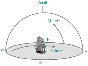
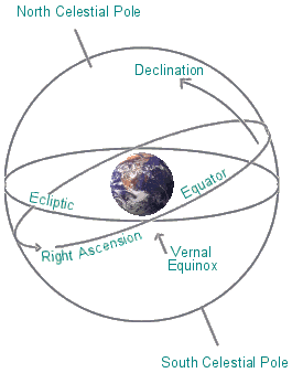
There are two primary ways to describe a precise position in the sky. One is called the Horizon System, also known as the Altitude-Azimuth System (Alt-Az). If someone says you don’t know your altitude from your azimuth, then they probably want to fight you and take your grog. The other celestial address system is the Equatorial System which uses coordinates of Right Ascension and Declination (R.A. Dec).

Horizon, or Altitude-Azimuth Coordinates
This method is subjective, that is it describes positions from the observer’s point of view. For example, when the Moon is half-way between the horizon (down low) and the zenith (up high) from our point of view, we say it has an altitude of 45 degrees. When it is due south, we say it has an azimuth of 180 degrees (N=0, E=90, S=180, W=270). These two measurements can describe a position like this: alt 45, az 180. A negative altitude describes objects below the horizon which hopefully is not your ship, and could result in a negative attitude.
 Equatorial Coordinates
Just as the latitude and longitude of a position on the Earth’s surface define a unique location for your home, regardless of the point of view, Right Ascension (R.A.) and Declination (Dec) of an object specify a unique position on the celestial sphere. For example, the star Sirius is always at R.A 6 hr 45 min (at least for our lifetime) and Dec. -16 degrees 43 minutes. Equatorial coordinates describe a star’s permanent mailing address.
Declination
This is a measurement of degrees above or below the celestial equator. It ranges from -90 degrees at the south celestial pole to +90 degrees at the north celestial pole.
Right Ascension
This is the hour angle measured along the celestial equator eastward from the node of the vernal equinox. It is measured in hours and minutes from 0 to 24 hours. The node of the equinox is the point where the Sun crosses the equator on its yearly trip northward in the spring. Don’t confusion the vernal equinox with the autumnal equinox. That would be Wrong Ascension.
 Sidereal Time
This method of measuring time is related to Right Ascension because it is a clock that keeps track of the angle, measured in hours, minutes, and seconds, from the vernal equinox node to the observer’s local meridian. Sounds simple right? No of course not. First you have explain what you mean by vernal and equinox, and node. But everyone knows what you mean by local meridian right? Of course not. By the time you got to node they had already stabbed you in their mind five times.
The daily motion of the point on the sky where the Sun hangs out on the first day of spring provides a handy measure of the rotation of the Earth with respect to the distant stars instead of the Sun. Relative to the stars the Earth moves quite a ways around in its orbit of the Sun each day therefore the sidereal clock (star clock) runs a tiny bit faster than our regular clock (sun clock) by about four minutes per day. So it’s kind of like having a crappy watch but in a good way.

To astronomers Local Sidereal Time is useful because it corresponds to the coordinate (address) of Right Ascension of celestial bodies that are presently on the local meridian. Put another way, the Right Ascension of a star is the hour, minute, and second it will cross your meridian (due south), in sidereal time. The end result is that you can check what objects are due south, and that tells you the sidereal time. Compare your local sidereal time to what time it is back home (your good watch) and you know how far you’ve traveled east or west.
Now get back to work. These decks aren’t going to swab (mop) themselves.

Alternate plan: GPS
Carpe Noctem.


March 2, 2014
Astronomy